Brava - Small but beautiful
The smallest inhabited island in the Cape Verdean archipelago, known for its picturesque villages and stunning scenery.
Brava Island
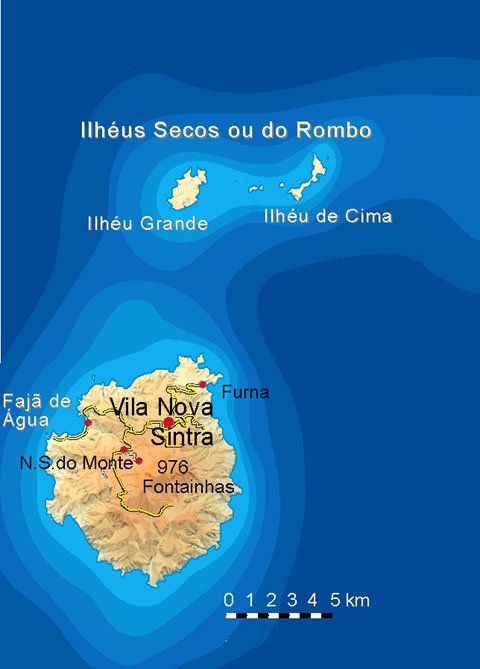
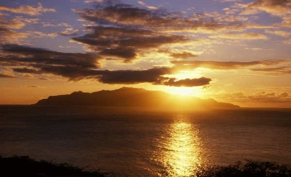
Brava is the smallest inhabited island of the Cape Verdean archipelago, but it is not to be underestimated. The almost circular island has a diameter of about 10 kilometers and accommodates its 6,800 inhabitants on just 64 square kilometers. Situated in the shadow of Fogos, 20km away, the clouds gather around the 976m high Monte Fontainhas. The resulting humidity is the reason why Brava is rightly called the “Island of Flowers”.
The tropical wet island offers a variety of plants, especially from October to February: Dattel and coconut palms, oleander bushes, hibiscus, almond, and jacaranda trees are native here. Brava is the place to be if you are looking for a change from the often desert-like islands of Barlavento. However, the increasing drought of the last few years has made Brava more arid in the summer.
Brava is a bit off the beaten track and is, therefore, rarely visited. One reason for this is that the island is only accessible by boat. The airport (at Ponta Espradinha, about 1 km southwest of Fajã d’Água) was built with great hope and opened in 1992. However, the strong winds caused problems during take-offs and landings. As the number of passengers remained low, the airport was closed after a few years.
Therefore, there are only a few organized trips to Brava. So, the island is reserved for individualists. Beach vacationers looking for secluded bays are out of luck here. The only bathing opportunities are the ocean pools at Fajã d’Água. But even here, swimming is not possible with strong waves. For hikers, however, the hilly island is beautiful. Numerous old maultier trails, often paved and usually in good condition, crisscross the highlands. Since there is little signage, you should always have a map or a navigation device with you.

Visitors arrive by boat at the port of Furna (approx. 600 inhabitants), protected by high cliffs. In 1843, the island’s main port was moved here from Fajã d’Água. Furna has little to see, so most people continue to visit Nova Sintra. A paved road winds in wide curves for 7 km to Nova Sintra. But the hiking trail leading up the mountain is much nicer and shorter.
The capital of Brava is at an altitude of about 500 m, and the air stays cool even in the summer. This is also where most of the tourist accommodation is located. Several small hotels and guesthouses, some newly built or renovated, are scattered throughout the city. If your ferry arrives late in the evening, you should book at least the first night. Please note that the ferry schedules are approximate. Deviations are the rule rather than the exception. In the city center, on Praça Eugénio Tavares, there are several restaurants and small hidden bars. Tip for dinner: Try the traditional Brava cuisine (chicken or fish).
- Current information about the island: www.brava.news (only in Portuguese).
- Transportation: CV Interilhas (www.cvinterilhas.cv) offers ferry service every 1-2 days between Brava, Fogo, and Santiago.
More information about the other islands of Cape Verde can be found here. Everything you need to know about traveling to the Cape Verde Islands can be found in our blog article!
Vila Nova Sintra
Vila Nova Sintra, the capital of Brava with about 1,500 inhabitants, is often called the most beautiful city in the Cape Verdean archipelago. Its location 500m above sea level provides a pleasant climate all year round. Attracted by this, many wealthy citizens of the neighboring islands built summer residences in the 18th and 19th centuries. Century summer residences here. Thus, the village was named after the Portuguese town of Sintra in the mountains near Lisbon, where the aristocracy resided during the summer (Nova Sintra => “New Sintra”). Even today, you can find well-kept sobrados with small gardens in the town, which indicates a better financial situation than on other islands. The streets are laid out in a checkerboard pattern, and the main road, with its green median and iron street lamps, still exudes a unique flair.
The main streets meet at the park-like Praça Eugénio Tavares. Here, you will find the town hall, a modern Nazarene church, and a music pavilion. In 2015, the square was adorned with a pavement mosaic depicting the symbols of the island: a caravel represents the era of voyages of discovery, a hibiscus blossom the title “Island of Flowers,” a whale symbolizes the emigration of fishermen who tried their luck on American whaling ships. A note commemorates the Morna poet Eugénio Tavares.
Born in Nova Sintra, the musician and poet (1867-1930) was an essential artist of the Cape Verdean culture. He wrote and composed some of the most famous mornas with texts in Kriolu. His house is located on Rua da Cultura. It is said that he liked to spend his afternoons in his rose-bedecked garden, chatting with passers-by. The traditional house is now a museum. In the Casa Museu Eugénio Tavares, you can see valuable furniture and furnishings that initially came from a palace in Madeira. In 2006, a monument to the poet was erected in the garden by local artist Domingos Luísa (www.eugeniotavares.org).
Nearby, a stone replica of the caravel used by Columbus to discover the New World awaits your visit. The Santa Maria is decorated with flowers on the day of St. John’s Day in June, and the locals celebrate around the monument. From the deck of the ship, you can enjoy a beautiful view.
From Vila Nova Sintra, there are several destinations to discover in the surrounding area. To the southeast are the villages of João d’Nole and Mato Grande. In João d’Nole, you should visit the Igreja Santa Antão, located on a hill overlooking the town and surrounded by a green, hilly Nebellandscape. Mato Grande has a magnificent view of the eastern coast of Brava.
Video about the flower island Brava
Sights on Brava
Fajã d’Água
On the west coast lies the sleepy village of Fajã d’Água (300 inhabitants). Tropical flair with banana trees and coconut palms by the sea awaits you here. The climate in this coastal town is sultry. In the water-rich valley, sugar cane is grown and processed into grogue.
In the 19. In the 19th century, the port was an essential center for whaling. Until 1843, it was Brava’s main port. It is in a bay where bizarre black rocks rise from the glassy water. American whalers used it to take provisions on board and to recruit sailors. These often used the opportunity to emigrate to the USA.
The place has a long row of houses with a few pensions behind the stony beach. A few bars attract day trippers. A turquoise church stands on a pedestal at the northern entrance to the village. The beach is not suitable for swimming, but about 1 km in a southerly direction, the rocks form a natural sea bath.
Fonte de Vinagre
In a wide valley below Nova Sintra, south of the village of Santa Bárbara, lies the Fonte de Vinagre. If you come to Santa Barbara by car, a narrow paved road leads from the village chapel to the former bathhouse, about 200 meters lower in the valley. You can also hike directly from Nova Sintra to Santa Barbara if you are a good walker.
The fluoride and carbonated water has a slightly acidic taste. It is said to have healing properties, so the sick came here to bathe. However, the times in which the spring gushed vigorously are over. The cube-shaped bathhouse from the 19th century is slowly decaying. It is slowly but surely falling into disrepair. There are still terracotta men’s heads on the corners of the brick roof, all with their mouths agape. About 100 meters below the bathhouse, there is a water tap.
The beautiful landscape around the spring and the bathhouse with its tall trees invites you to stay. In the past, the Fonte de Vinagre was also used to irrigate the fields, as evidenced by a system of levadas (water channels) leading from the half-decayed bathhouse, which supplied the surrounding terraced fields with the acidic water.
João d’Nole and Mato Grande
A little above Nova Sintra are the two villages of João d’Nole (also João da Noly) and Mato Grande. João d’Nole is a picturesque little village with well-kept houses and many orchards. About 60 people are living here. A small, turquoise church stands on a hill: the Igreja Santo Antão. The picturesque village, with its narrow alleys and neat houses, can be reached from Nova Sintra in a 20-minute walk along a steep cobblestone path. It starts near the no longer-used market hall.
After another 30 minutes, you reach Mato Grande. With its 400 inhabitants, Mato Grande is a bit larger and not as picturesque as its sister village but offers a magnificent view of the island of Fogo and the entire eastern coast.
Nossa Senhora do Monte
With its 150 inhabitants, the village lies in the northwestern part of the central highlands on a mountain ridge. From the square in front of the Catholic church of the same name, you have a beautiful view of the upper part of the Fajã d’Água valley.
Cachaço
Cachaço is located at an altitude of 592 m in the mountains, 4 km south of the capital, Nova Sintra. Here live about 200 inhabitants. Cachaço is the second most southerly settlement in the Cape Verde Islands after nearby Tantum. About 4 km further south is the southernmost point of the Cape Verde Islands, Ponta Nhô Martinho.
On a clear day, the neighboring island of Fogo can be seen from here. From Cachaço comes a fresh cheese, for whose production the milk of goats and cows is mixed. It is sold in Nova Sintra and served in the local restaurants. You can also buy it in the small local dairy. Hikers can reach Cachaço from Nova Sintra over the mountains on a scenic but challenging route in about 4-5 hours.
You can find more information about the other islands of Cape Verde here. Everything you need to know about traveling to the Cape Verde Islands can be found in our blog article!

